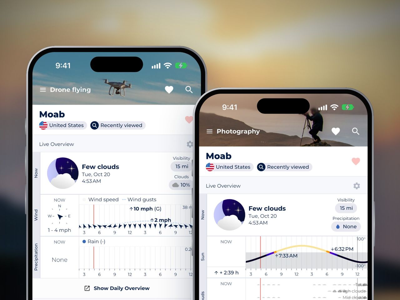
Good drone photography needs four things from the weather: light wind at the height you fly, low sun, a sky with some texture in it, and dry air. The catch is that the wind at 100 m can be very different from what you feel at the launch spot: after a clear night, the air at your feet can be calm while the wind above it is strong. [11]
Rain is a hard stop for most consumer drones: DJI’s Mini, Air and Mavic models, for example, have no water resistance rating and shouldn’t fly in it. [6]
| Factor | Good for drone photos | Think twice | Stay on the ground |
|---|---|---|---|
| Wind | Light at flying height, not only at the ground | Calm at the ground after a clear night: check the wind at height first | Gusts at flying height close to or above your drone’s rated limit |
| Light | Golden hour, low sun | Midday sun for most scenes | Twilight or night without lights that show where the drone is |
| Clouds | High or mid cloud, such as cirrus and altocumulus | Thick, flat overcast, or a low cloud base that caps your height | Cloud or fog at your flying height |
| Rain, fog and haze | Dry, clean air, such as the day after a cold front | Haze or mist | Rain, or visibility under 3 statute miles (US commercial) |
| Cold | Battery warmed before takeoff | Air below 15 °C (59 °F), when batteries start to drain faster | Below your drone’s operating range |
Wind pushes the drone, and the camera with it. And the wind at flying height keeps its own daily rhythm, different from the one you feel standing at the launch spot.
On a clear night the ground cools, and so does the air touching it. That cold layer sits still and cuts itself off from the air above: the wind up there can stay strong while the wind at the ground goes calm. [11] On some nights the wind just above the cold layer even speeds up, into what meteorologists call a low-level jet. At a flat site in the Netherlands this happens on about one night in five, with the strongest wind usually 140 to 260 m up, at 6 to 10 m/s. [12] In Kansas it was often at or just below 100 m, mostly at 7 to 10 m/s. [13]
So a still sunrise after a clear night is the moment to check the wind at height, not to trust the flag. If the forecast shows calm at the ground and 8 m/s at 100 m, the 8 m/s is what the drone meets as it climbs.
Once the sun heats the ground, the air starts to mix, and the faster wind from above reaches the surface. [11] Gusts usually begin in the late morning, peak in the afternoon and die down by early evening. [11] This stirring is strongest in the early afternoon, when the ground is hottest, and weakest at night and in the early morning. [14] Over dry, rocky ground it reaches 8,000 to 12,000 ft up. [11] Expect a sunny afternoon over open, dry ground to shake a drone around.
That leaves two windows for a shoot: the first hour of light, if the wind at height is light, and the early evening, once the afternoon gusts have dropped. The first hour of light is also golden hour, with the sun under about 6°. [9] In summer the calm evening can come well before the evening golden hour, so check both before you pick a time. Plan for the early afternoon to be the bumpiest time of day.
On a sunny day the land heats faster than the sea, and a breeze sets in from the water. It’s strongest from mid-day through mid-afternoon, typically about 6 m/s (22 km/h), and it “can die in the late evening before the sun sets”. [15] At night a weaker land breeze can blow back out to sea. [16] For a coastal shoot, that is one more reason to fly early or late.
In the mountains, wind blows up the slopes and valleys by day and down them at night. [17] The night wind down a slope is a thin layer of cold air, with its fastest wind only 1 to 15 m above the ground. [17] If you launch from a slope at dawn, expect the wind to change within the first few dozen metres of the climb.
Every drone maker lists a maximum wind resistance. DJI’s Mini 4 Pro, for example, is rated for 10.7 m/s, about 24 mph. [5] Pilot Institute notes that published ratings like this tend to describe steady wind, and that experienced pilots add a buffer of around 30% to account for gusts. [18] So don’t plan a flight with the forecast wind close to the rating: leave room for the gusts on top of it.
The common mistake is to treat the rating as a limit you can fly up to. The drone also needs spare power to fly home against the wind on a draining battery. Fly out into the wind first, so the trip back, when the battery is lowest, has the wind behind it.
The ground slows down the air moving over it, so wind speed usually rises with height. [8] A gentle breeze at your feet can be a much stronger wind at 400 ft. Check the forecast wind at the height you plan to fly, and compare its gusts, not the average, with your drone’s rating. If the gusts at your flying height come close to the rating, don’t fly.
Modern drones hold position and a gimbal keeps the camera level, so a light breeze rarely shows in a single photo at a fast shutter speed. Wind shows the moment you slow the shutter: long exposures of moving water, traffic trails or blue hour scenes blur with even small movements. It shows in panoramas and bracketed exposures too, where the drone drifts between frames and the images stop lining up. And close to cliffs, trees or buildings, the wind turns into turbulence that shakes the drone however fast you shoot.
On a windy day, keep the shutter fast, raise the ISO a little, and leave long exposures for a calmer evening.
Light shapes a drone photo the same way it shapes any landscape photo, but the view from above changes which light works best.
During golden hour, the sun sits less than about 6° above the horizon. [9] Its light is warm and soft, and it throws long shadows that show the shape of hills, trees and buildings from above. Shadows are what give an aerial photo depth: without them, a landscape from 300 ft looks flat. Sonuby’s guide to golden hour photography explains how long it lasts where you are and how to calculate it.
Looking straight down, the high sun of midday gives short shadows and strong colour. That suits patterns such as fields, beaches, pools and road junctions, and shallow, clear water, where a high sun lights up the seabed. The early afternoon that follows is when the wind mixes down hardest, [14] so keep these shots for calm days.
The cool light just after sunset falls in civil twilight. In the US, a drone flying under the commercial rules (Part 107) needs anti-collision lights visible for at least 3 statute miles during civil twilight and at night. [2] Civil twilight is defined there as the 30 minutes before sunrise and the 30 minutes after sunset. Recreational flyers must keep the drone within visual line of sight, [3] which after dark you can only do with lights on the drone. Low light also means slow shutter speeds, which brings you back to the wind.
Clouds are what turn an aerial sky from empty blue into a scene, but which clouds matter more than how many.
The scarlet, orange and red of a strong sunset most often light up cirrus and altocumulus, the high and mid-level clouds. [19] They sit high enough to catch sunlight that hasn’t passed through the layer near the ground that holds most of the air’s dust and haze. [19] Low clouds such as stratus take on vivid colour only when the air below them is unusually clean. [19] Clean air matters most: it is the main ingredient common to brightly coloured sunrises and sunsets, and haze subdues the colour rather than adding to it. [19]
So read the cloud forecast by layer. Some high or mid cloud, little low cloud, and clean air is the evening worth driving out for. A sky of low, flat stratus on a hazy day stays muted.
A thick, flat overcast gives soft, even light. That works for forests, waterfalls and anything with deep shade, but the sky itself turns grey: tilt the camera down and leave the sky out. Scattered cloud helps in daylight too, since its shadows on the ground add contrast to wide landscape shots.
A low cloud base limits how high you can go. In the US, a commercial flight must stay at least 500 ft below the clouds and 2,000 ft away from them horizontally. [1] For drone photography, the low cloud forecast tells you about your ceiling, and the high cloud forecast tells you about the colour.
Not most consumer drones. DJI’s Mini, Air and standard Mavic ranges, for example, have no IP rating, which is the rating that says how well a device keeps out dust and water, and they aren’t designed to fly in rain. [6] Some enterprise drones, such as DJI’s Matrice 30 series (IP55), are rated to fly in rain, but even they are only water-resistant, not waterproof. [6]
If your drone has no rating, count drizzle as rain. Rain ruins the photo too: a single drop on the lens leaves a soft blur in every frame until you land and wipe it off.
Valley fog is predictable: it forms on nights with clear skies and light wind. The cooled air sinks down the hillsides and pools in the valleys. [20] If the gap between the temperature and the dew point is already small after sunset, a clear sky lets the ground lose heat fast, and this radiational cooling takes the air quickly toward saturation. [21] The fog is thickest around daybreak and usually clears within a few hours after sunrise, [20] sometimes lifting into low cloud first as the ground warms. [21] In calm winter weather, valley fog can last for several days. [22]
So the evening before, look for a clear night, light wind and a dew point close to the temperature, and plan to be in the air at sunrise. Launch from a hill above the fog, not from the valley floor inside it. You still have to keep the drone in sight: US recreational pilots must fly within visual line of sight, [3] and commercial pilots need at least 3 statute miles of visibility from where they stand. [1]
Haze lowers contrast and washes out distant mountains. Behind a cold front, visibility improves rapidly to good or excellent. [23] Stagnant air does the opposite. When a cool air mass settles over a region and the wind goes light, haze can become noticeable after as little as 48 hours over the eastern US, and it stays until rain washes it out. [24]
For long views from the air, prefer the day after a cold front to a day when still air has sat in place for two days or more.
Drone batteries lose power in the cold. The chemical reactions inside a LiPo battery slow down, and DJI says this starts below 15 °C (59 °F). In extreme cases, a battery can drain below 3 V, which cuts thrust or even shuts the battery off. [25] DJI’s Mini 4 Pro is rated to fly between -10 °C and 40 °C (14 °F to 104 °F). [5]
So a cool autumn morning already counts as cold for the battery. DJI’s winter advice is to warm batteries to above 15 °C before takeoff, hover for about a minute after takeoff to warm them fully, and keep more battery than usual for the return home. [7] Expect shorter flights, and land early.
Cold brings one photo problem too: the lens can fog up, for example when you bring the drone out of a warm car. [7] Give it a few minutes to adjust to the outside air before you fly.
Weather isn’t the only limit. In the US, recreational and commercial pilots both fly at or below 400 ft. [1] [3] In the EU, drones in the open category stay below 120 m above the ground. [4] And some of the most photogenic places are closed to drones: US national parks, for example, prohibit launching, landing or flying them. [10] Check the rules for your spot before you plan the shoot around the weather.
With wind at height, gusts, cloud layers, visibility and the light all mattering at once, an everyday weather app leaves a lot of guesswork. Sonuby has two reports made for this: the Drone Flying Report for whether you can fly, and the Photography Report for whether the light will be worth it. Both cover any place in the world, up to 14 days ahead.
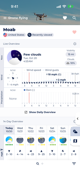
The Drone Flying Report puts wind and gusts first, followed by rain, visibility, fog risk and clouds for the next hours.
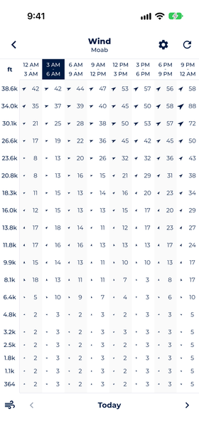
The altitude wind forecast shows the wind at each height above the ground, hour by hour, so you can see a calm dawn with strong wind above it.
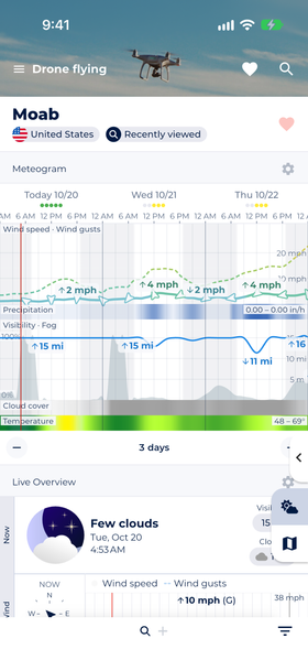
The meteogram lines up wind, rain, visibility and cloud hour by hour, so you can spot a calm, dry window at a glance.
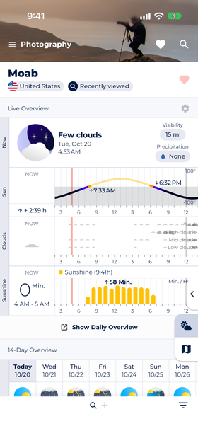
The Photography Report shows when the sun rises and sets, golden and blue hour, and the cloud and sunshine forecast for the same hours.
To pick a flying window:
You can download Sonuby for free on iOS and Android.


A forecast picks the day and the hour, and the drone has the last word. If it drifts on the hover, slows on the way back, or the battery drops faster than usual, bring it home and land. The forecast will show you the next window.
Not most consumer drones. DJI's Mini, Air and standard Mavic models, for example, have no IP rating for water and aren't designed to fly in rain. Check your drone's IP rating before you fly in wet weather. Some enterprise drones, such as the DJI Matrice 30 series (IP55), can fly in rain, but they're water-resistant, not waterproof.
Wind is too much once the gusts at your flying height come close to your drone's rated wind resistance. A DJI Mini 4 Pro, for example, is rated for 10.7 m/s (about 24 mph), and ratings like that tend to describe steady wind. Wind is usually stronger at height than on the ground, and after a clear night it can be strong at 100 m while the ground is calm, so check the altitude forecast and keep a margin for the flight home.
Golden hour, just after sunrise and just before sunset, is the best time for most drone photography. The low sun throws long shadows that give aerial shots depth, and the wind is often lighter than in the afternoon, when gusts peak. Midday works for top-down shots of patterns and clear water.
Drone photography is a kind of aerial photography: taking photos from the air. When it's done with a drone in particular, it's also called UAV photography, after the unmanned aerial vehicle that carries the camera.
In the US, drones fly at or below 400 ft and within the pilot's visual line of sight. Commercial pilots under Part 107 also need 3 statute miles of visibility and must stay 500 ft below clouds. In the EU's open category, the limit is 120 m above the ground. Many places, such as US national parks, ban drones altogether.
Yes. Sonuby's Drone Flying Report shows wind, gusts, wind at altitude, rain, visibility and cloud cover up to 14 days ahead, and its Photography Report adds sunrise, sunset, golden hour and cloud layers. Together they show when you can fly and when the light will be good.
Resources:
[1] 14 CFR § 107.51, Operating limitations for small unmanned aircraft, Cornell Law School
[2] 14 CFR § 107.29, Operation at night, Cornell Law School
[3] Recreational Flyers & Community-Based Organizations, FAA
[4] Open category: low-risk civil drones, EASA
[6] Flying a Drone in the Rain: A Guide to IP Ratings, Heliguy
[7] DJI Enterprise’s Winter Drone Guidelines, DJI Enterprise
[9] The Golden Hour: Sunrise, Sunset and Photography, Sunrise-Sunset.org
[10] Uncrewed Aircraft in the National Parks, National Park Service
[12] A climatology of nocturnal low-level jets at Cabauw, Baas et al., KNMI
[14] Fire Weather, Chapter 6: General Winds, hosted by the NOAA National Weather Service
[15] Local Winds, ATSC 113 Weather for Sailing, Flying & Snow Sports, University of British Columbia
[16] The Sea Breeze, NOAA JetStream
[18] Weather Planning for Drone Pilots, Pilot Institute
[19] The Colors of Sunset and Twilight, Stephen F. Corfidi, NOAA Storm Prediction Center
[20] Weather in Action: Valley Fog, NOAA National Weather Service Binghamton
[21] Fog Ingredients, NOAA National Weather Service
[23] Factsheet 10: Air masses and weather fronts, Met Office
[24] Haze Over the Central and Eastern United States, Stephen F. Corfidi, NOAA Storm Prediction Center
