
Clouds may be something we don’t pay much attention to, but when thought of on a universal scale, they are among the most interesting features of the planet we call home because not every planet has clouds. But here on Earth, the constantly shifting and evolving patterns of clouds play a significant role. [1]
“Different kinds of clouds have different effects on temperature; they cool or warm the Earth below.”
Aside from simply looking magnificent, clouds are among the key regulators of Earth’s global temperature. Different kinds of clouds have different effects on temperature; they cool or warm the Earth below.
Some clouds are responsible for helping to cool the Earth. They intercept rays of sunlight, and either disperse the energy across a large surface area or reflect it back towards the sun. Both effects help to cool the planet. [1]
Other clouds are able to warm the Earth because they trap heat like a blanket on a cold night. These insulating clouds prevent heat from leaving through the atmosphere, maintaining a warmer temperature. [1]
Clouds aren’t only able to affect temperature. Storm clouds, for example, are responsible for creating more noticeable changes in the weather. Aside from causing rainfall and lightning, storm clouds also help disperse energy across the planet from warm areas near the equator down to the icy poles. [1]
So, although clouds may be far away, given that they exist high above us in the atmosphere, they become an essential component of our daily lives through influencing the weather. Thus, it’s essential to demystify clouds, which we will do in this article by exploring different cloud types.
An average cumulus cloud (the fluffy white cloud type) weighs the same as a jumbo jet - about 500 tonnes.
The three main types of clouds are cumulus, stratus, and cirrus. Cumulus clouds are fluffy and cotton-like, forming through thermal convection. Stratus clouds appear as horizontal sheets covering large portions of the sky. Cirrus clouds are high-altitude formations made of ice crystals, appearing thin and wispy due to high winds.
Clouds form when air reaches its saturation point through evaporation and condensation. Evaporation increases air humidity until it reaches maximum capacity. Condensation occurs when warm, moisture-rich air cools, causing water vapor to condense into tiny droplets or ice crystals. This typically happens when air rises and cools, encounters cooler air masses, or flows over cool surfaces like mountains.
Nimbus clouds are the primary rain-bringers. Cumulonimbus clouds (thunderheads) produce thunderstorms with heavy rain and sometimes hail. Nimbostratus clouds create continuous, moderate precipitation, appearing as gray layers covering the entire sky. While other cloud types may occasionally produce light drizzle, nimbus clouds are responsible for most significant rainfall.
Clouds regulate Earth's temperature through two opposing effects. Low and mid-level clouds (cumulus and stratus) cool the Earth by reflecting sunlight back to space. High-altitude clouds (cirrus) warm the Earth by trapping heat like a blanket. The overall impact depends on cloud type, altitude, thickness, and location, making clouds critical factors in Earth's climate system.
Yes, clouds provide valuable weather indicators. Cirrus clouds often appear before weather fronts, signaling changing conditions. Darkening, growing cumulus clouds indicate developing thunderstorms. Small, scattered cumulus suggests stable conditions. Extensive overnight cloud cover typically means warmer temperatures, while clear nights result in cooler temperatures. Cloud observation remains a useful tool for short-term weather prediction.
Lenticular clouds are stationary, lens-shaped formations that often resemble flying saucers. They form when moist air flows over mountains, creating a standing wave pattern. The cloud continuously forms at the wave's crest while dissipating downwind, creating an illusion of a hovering object. Their smooth, oval shape with well-defined edges creates the distinctive UFO-like appearance that has sparked many mistaken UFO sightings throughout history.
Altitude directly influences cloud types and naming conventions. High clouds (20,000-43,000 ft) like cirrus form as ice crystals and receive the prefix 'cirro-'. Mid-level clouds (6,500-20,000 ft) like altocumulus may contain both water and ice and use the prefix 'alto-'. Low clouds (below 6,500 ft) consist mostly of water droplets and don't receive special prefixes. Altitude also affects temperature, pressure, and moisture availability—all critical to cloud formation.
Cumulonimbus clouds strongly indicate severe weather approaching within 30-60 minutes. These thunderheads bring heavy precipitation, lightning, strong winds, and sometimes hail or tornadoes. Despite their intensity, isolated cumulonimbus storms typically pass within 2 hours. The anvil-shaped top points in the storm's direction of movement, helping predict which areas will be affected next.
A typical cumulus cloud weighs approximately 500 tonnes (1.1 million pounds)—about the same as a jumbo jet. This surprising weight comes from countless tiny water droplets suspended in the air. Despite this mass, clouds float because the water is distributed across a vast volume, making the cloud only slightly denser than surrounding air. Upward air currents easily keep these droplets aloft due to their slow fall speed.
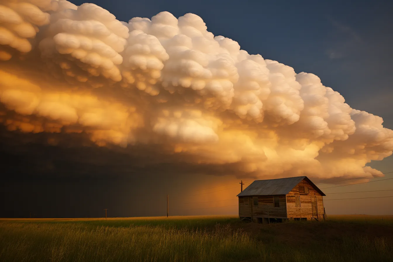
Mammatus clouds form when cold, dense air pockets sink through a cloud's base, creating distinctive pouch-like structures. This downward development is opposite to how most clouds form. They typically appear after thunderstorms, extending from cumulonimbus anvils, though they can form under other cloud types. While visually dramatic, mammatus clouds themselves don't produce severe weather but indicate that a strong storm has recently passed through.
Yes, Sonuby Weather offers detailed cloud forecasts for weather enthusiasts and professionals. The app provides predictions for low, mid, and high clouds, as well as specialized altitude cloud forecasts at various levels up to approximately 38,000 feet. These comprehensive cloud predictions help users understand upcoming weather patterns, plan outdoor activities, and even assist pilots and aviation enthusiasts in flight planning. Sonuby's cloud coverage maps and weekly meteograms make it easier to visualize and track cloud formations over time.

Clouds form when air vapor reaches what is known as the saturation point. Simply put, this is when the air is holding as much moisture as it can, or when it is saturated. [2] This can happen through either evaporation or condensation.
Evaporation can cause cloud formation because as water is absorbed into the air, the humidity or water content of the air grows. This means that the saturation point is reached when the moisture level has reached a maximum volume. [2]
Condensation can cause cloud formation by having absorbed moisture condense out of vapor. This occurs when the air cools, which creates liquid water droplets out of the moisture-rich air. [2]
Altitude plays a strong role in the formation of different cloud types, as well as their function and effect on daily life. The naming of cloud types also partially depends on their altitudes. We will explore this concept more in a short while.
The word “cloud” comes from the Old English words “clud” or “clod” meaning lump of land or lump of rock. In the 13th century, the meaning was extended to apply to the lumps of water in the sky.
When talking about cloud types, it’s important to understand how they interact with the atmosphere at different altitudes. Each type of cloud is defined by its shape and size, and each type has a distinct relationship with the weather.

These are the clouds that most people think of when imagining a cloud—distinct, fluffy puffs of vapor. These clouds are common all over the world with the sole exception being frosty Antarctica, where it’s too cold for the liquid water that composes these clouds to exist. [3]
These clouds are formed through currents in the air as a result of thermal convection, which occurs when hot air rises until it cools and forms water droplets. As a result, cumulus clouds are often seen in the middle part of the sky in good weather. They occur when the sun is shining enough to warm the earth and subsequently create warm air on the ground. This air then rises through the atmosphere and forms convection currents. [3]
These clouds are formed through advective cooling, when warm air suddenly travels into a colder location like above the sea or throughout mountains. When these clouds are below 50 ft above the surface of the Earth, they’re often called fog. [3]
Stratus clouds are also common worldwide, and may contain small amounts of rain. However, they’re unlikely to give off more than a light drizzle. [3]
Stratus clouds can join with cumulus clouds to become stratocumulus clouds. These are a semi-continuous layer of clouds with the fluffiness of cumulus clouds and the connected shape of stratus clouds. [3]
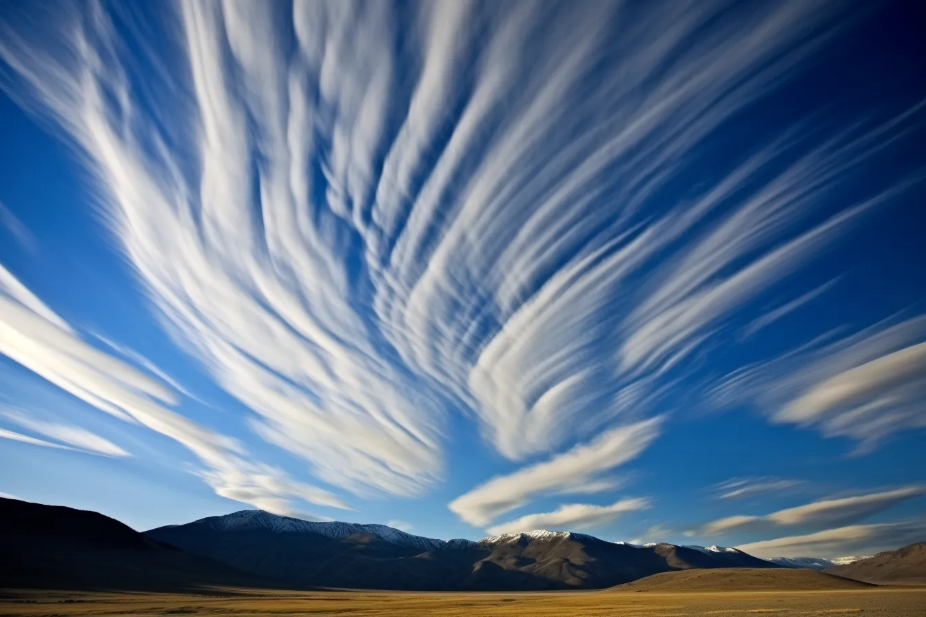
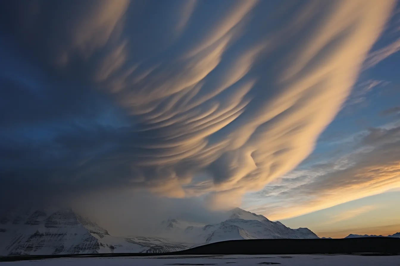
Cirrus clouds are the final of the three main groups. They’re distinct in that they’re made of solid ice crystals. These clouds form the highest of all cloud groups and, as such, are also exposed to high winds. These winds disperse the ice crystals to give the signature wispy look of a cirrus cloud. [3]
Cirrus clouds are also important for weather but have no precipitation that reaches the ground. [3]
The psychological phenomenon of seeing objects in clouds is called pareidolia.
Clouds can be defined by their altitude, as explained earlier. Clouds very high in the sky are given the prefix cirro-, which can be confusing as “cirrus” is also a type of cloud. For example, a cloud with its stratus shape high in the sky is often dispersed into a light, milky mist, which is called a cirrostratus cloud.
Clouds in the middle range of altitude are given the prefix alto-. Altocumulus or altostratus clouds are distinct shapes within the middle range of altitude.
Low clouds don’t have a special prefix. They’re always just stratus clouds.
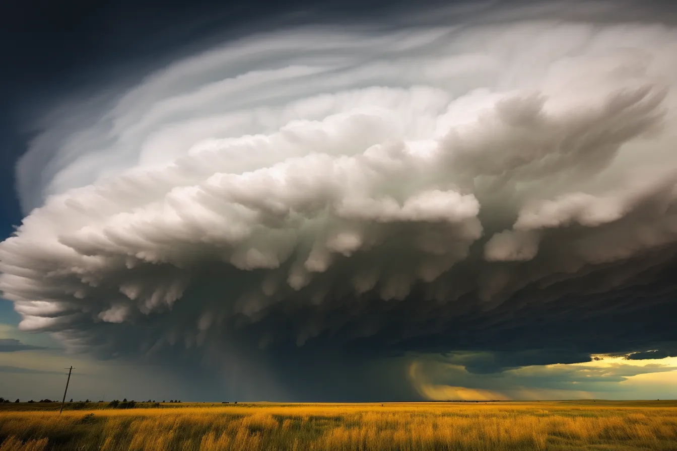
Another subtype of cloud is the nimbus. These are the clouds that bring rainfall and can have either a cumulus shape (cumulonimbus) or a stratus shape (nimbostratus).
While we’ve covered the three most common cloud types (and then some!), you may also occasionally spot some different clouds.
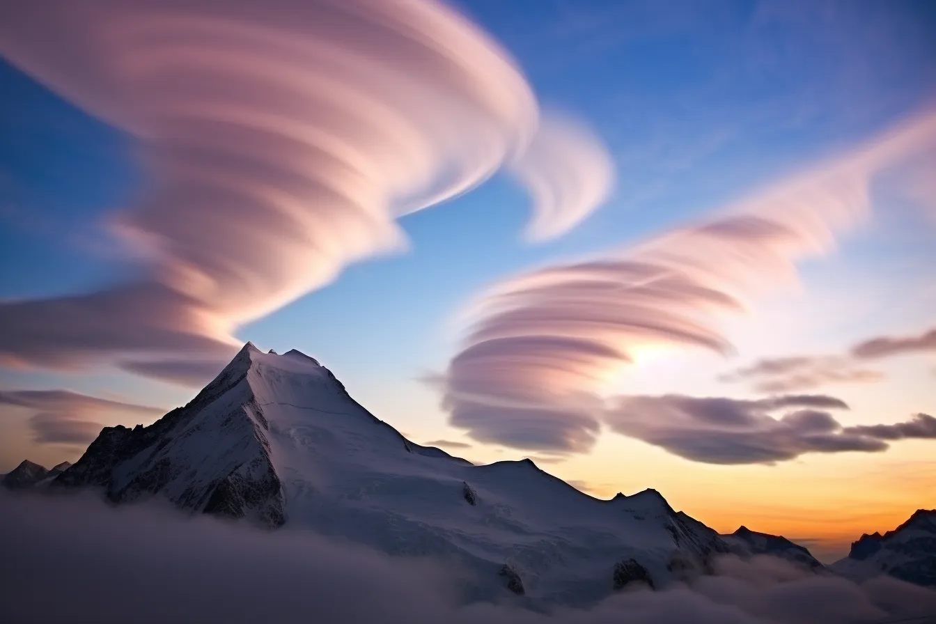
Lenticular clouds often stand out as they look like UFOs. These flying saucer shaped clouds are usually formed over mountainous terrain. [4]
Another interesting cloud type is mammatus clouds. These clouds include small bulging pouches underneath other clouds, often in a line or series. [5]
As we’ve already learned, some clouds are associated with different types of weather. For example, spotting a cumulus cloud means rain is unlikely. However, spotting a cumulonimbus cloud means rain is almost certainly on the way.
Although weather prediction is possible from simple cloud spotting, it’s hard to do well without practice, which is where weather prediction apps can be helpful.
You could call a clear blue sky cloudless or, if you want to impress someone, you could call it enubilous.
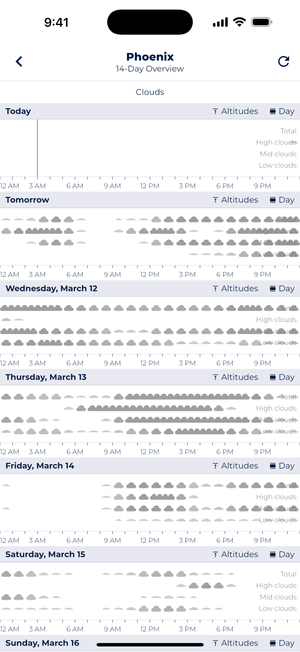
Sonuby’s 14-day cloud forecast displays high, mid, and low cloud coverage throughout each day, helping you track and plan outdoor activities based on expected cloud conditions.
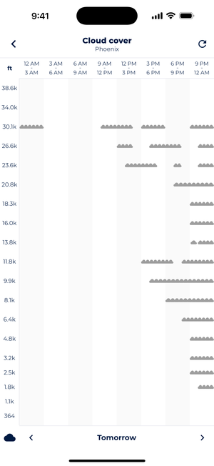
Sonuby’s detailed cloud altitude forecast shows cloud formation at specific elevations from ground level up to 38,000 feet.
While learning to identify specific cloud types takes practice, Sonuby’s cloud cover forecasts can help support your understanding of general cloud patterns and their relationship to weather changes.
Sonuby doesn’t identify specific cloud types (like cumulus or cirrus), but instead provides valuable information about overall cloud coverage at different altitudes. The 14-day overview displays cloud density across three altitude ranges – high, mid, and low – showing you when clouds are likely to be present at each level throughout the day.
For those interested in more detailed atmospheric conditions, the altitude-specific view maps cloud coverage across multiple specific elevation levels from near ground level up to 38,000 feet. This vertical profile gives you insight into the distribution of clouds throughout the atmosphere, which can complement your own observations of cloud types.
By comparing the app’s cloud cover forecasts with your own cloud type observations, you can begin to recognize patterns between general cloud coverage and specific cloud formations. This practice can gradually improve your weather prediction skills while giving you a deeper appreciation for the complex relationship between clouds and weather conditions.
References:
[1] www.nasa.gov
[2] www.weather.gov
[3] www.epfl.ch