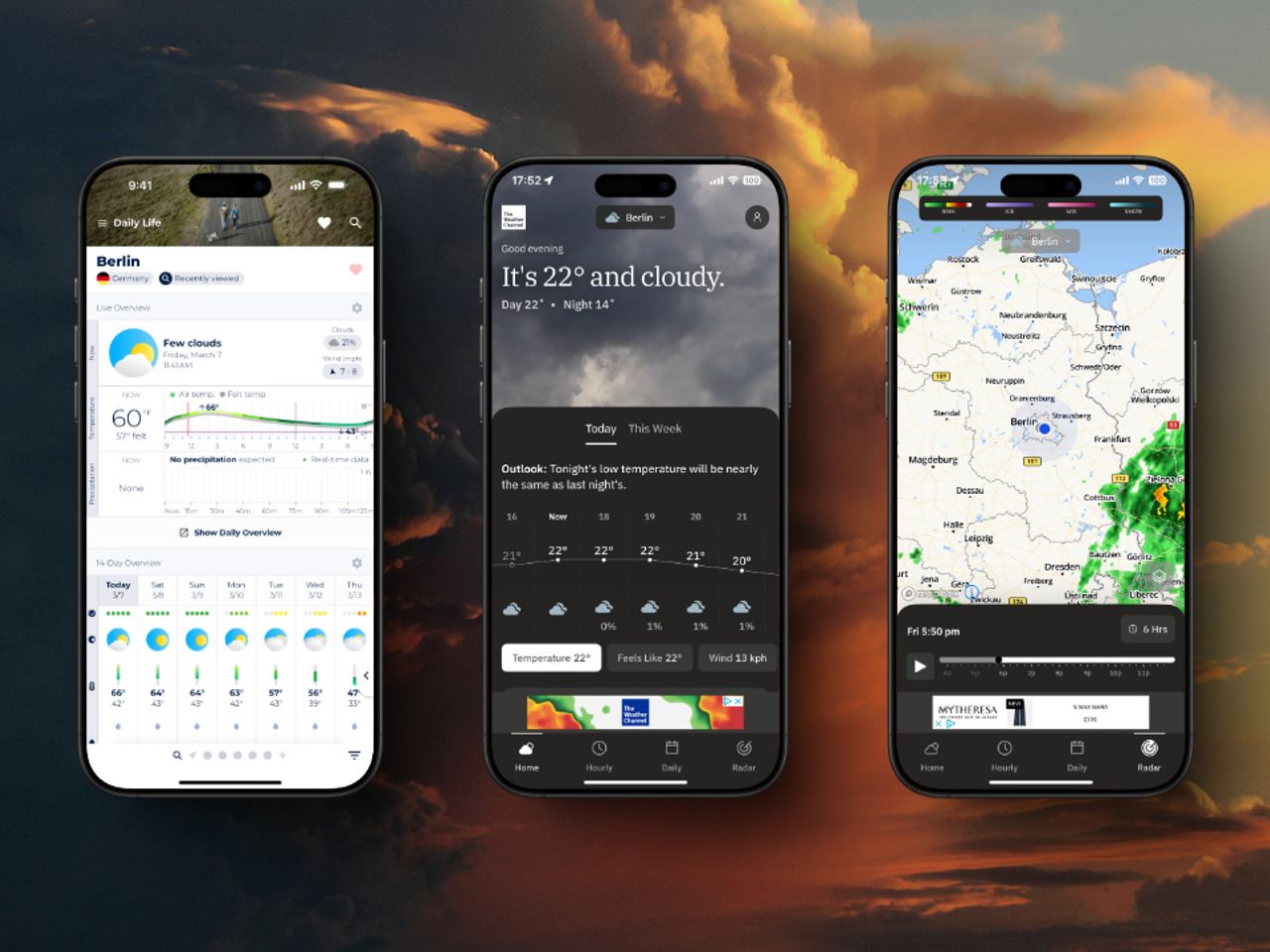
Finding a reliable weather app is as controversial as deciding whether to put pineapple on your pizza. Everyone seems to have their favorite, swearing it’s the most accurate, while giving the side-eye to those who prefer another app. But let’s face it - when it comes to weather, we need facts, not debates.
With more than 10,000 weather apps available worldwide, it’s hard to tell though which weather app will actually help you plan your day right.
In this article, we’ll find out what makes a reliable weather app and show you which ones you should try in 2026.
The foundation of any reliable weather app is its weather model and data sources. They form the basis for accurate forecasts and comprehensive weather information.
Weather models are complex mathematical representations of the atmosphere used to predict future weather conditions. They are typically developed and maintained by government agencies such as
These agencies use powerful supercomputers to process vast amounts of atmospheric data and provide a basic forecast that’s freely available to the public and to commercial weather providers.
The reliability of forecasts produced by weather models gets better every year.
As David Novak of the U.S. National Weather Service notes, these models have improved significantly over time, with forecast accuracy increasing about one day per decade over the past 40 years.
But the most reliable weather apps don’t rely solely on these government models. They improve their forecasts by incorporating additional data sources, such as
to identify patterns and improve forecasts.
This “secret sauce” of data optimization and interpretation is what separates the most reliable apps from the rest.
A truly reliable weather app will be transparent about its data sources and modeling techniques, allowing users to understand where their weather information is coming from.
By combining robust government models with additional data sources and advanced processing techniques, the best weather apps can provide more accurate and localized forecasts than ever before.
Reliable weather apps provide a range of forecast variables to give users a comprehensive understanding of upcoming weather conditions. These may include
The accuracy of these individual variables can vary significantly, even within the same weather application. This variation is due to the inherent complexity of each variable and the different methods used to predict them.
For example, temperature forecasts are generally more accurate than precipitation forecasts. This is because temperature changes tend to be more gradual and follow more predictable patterns.
Precipitation, on the other hand, can be highly localized and influenced by numerous factors (topography, atmospheric moisture content, atmospheric instability, etc.) that are difficult to model accurately.
Predictions of wind speed and direction fall somewhere in the middle in terms of accuracy. They’re typically more reliable than precipitation forecasts, but less reliable than temperature forecasts.
The time frame of the forecast also affects accuracy. Short-term forecasts (1-3 days) are generally more accurate than long-term forecasts (7-10 days) for all variables. This decrease in accuracy over time is more pronounced for some variables than others.
Example:
Let’s consider a hypothetical weather app’s performance over a month:
This example illustrates how different variables can have varying levels of accuracy, and how this accuracy diminishes over longer forecast periods.
The most reliable weather apps will be transparent about these differences. They may provide confidence levels for different variables or clearly indicate when long-term forecasts are less certain.
Some advanced apps even use ensemble forecasting, which runs multiple model scenarios to provide a range of possible outcomes, giving users a better sense of forecast uncertainty.
When evaluating a weather app’s reliability, it’s important to consider its performance on all of these variables, not just one or two. An app that excels at predicting temperature but consistently misses precipitation forecasts may not be the best choice for all users.
The ideal app will maintain high accuracy across all the variables it forecasts, while being clear about the limitations and uncertainties in its predictions.
Your location plays a crucial role in determining how reliable a weather app will be for you. Different geographical features and climate patterns can significantly affect the ease and accuracy of weather forecasting. Certain areas are inherently more difficult to forecast than others, such as
Coastal areas
Regions near large bodies of water, such as oceans or large lakes, often experience more variable weather. The interaction between land and water masses creates complex microclimates that can be difficult to accurately predict. Coastal areas can experience sudden fog, sea breezes that affect temperature and wind patterns, and storms that intensify or weaken as they move from water to land.
Mountains and Valleys
Mountainous regions present unique forecasting challenges. Changes in elevation can create local weather patterns that differ significantly from surrounding areas. Valleys can experience temperature inversions, while mountain peaks can generate their own weather systems. Orographic lift (when air is forced up a mountain slope) can cause precipitation on one side of a mountain range while leaving the other side dry.
Urban Area
Cities create their own microclimates due to the urban heat island effect. This phenomenon can lead to higher temperatures and altered precipitation patterns compared to surrounding rural areas. The complex landscape of buildings can also affect wind patterns, making accurate local forecasts difficult.
The best weather apps account for these geographic influences by
When choosing a weather app, it’s important to consider how well it works in your specific area. An app that excels at predicting weather for coastal cities might struggle in mountainous regions.
Some apps allow users to compare their predictions to actual observed weather, which can be a useful feature for evaluating local performance.
Keep in mind that no single app is perfect for all locations. The most reliable weather apps are those that perform consistently well in different geographic locations and are transparent about their strengths and limitations in different regions.
Now that we understand the factors that make a weather app reliable, let’s look at the three most reliable weather apps in 2026.
Keep in mind that while these apps are the top picks for this article based on overall performance, the best app for you may depend on your specific location and needs.
Sonuby uses meteoblue forecasts. Meteoblue's forecasting system is built on a foundation of diverse weather models. At its core are the NEMS (NOAA Environment Monitoring System) models, including the global NEMSGLOBAL and various regional high-resolution versions. To enhance coverage and accuracy, meteoblue also incorporates third-party models such as ICON from DWD, IFS from ECMWF, and GFS from NOAA. This multi-model approach allows for a comprehensive and nuanced understanding of atmospheric conditions.
To ensure historical consistency and improve forecast accuracy, meteoblue utilizes ERA5/ERA5T reanalysis data. They also integrate satellite-based datasets, such as SARAH-2 for solar radiation and IMERG for precipitation, to enhance their observational input. This combination of reanalysis and satellite data provides a robust foundation for their forecasting models.
Meteoblue offers global forecasts at 30 km resolution using NEMSGLOBAL, while providing higher resolution forecasts (4-12 km) for regional areas. This approach balances broad coverage with detailed local forecasts.
To refine raw model output, meteoblue applies Model Output Statistics (MOS) to correct systematic biases. They have also developed a Learning MultiModel (mLM) approach, which dynamically selects the most suitable model for specific locations and conditions, further improving forecast accuracy.
Comprehensive environmental modeling is achieved by incorporating soil data from SoilGrids, land use information from GFSAD and GLOBCOVER, and ocean data from ERA5 Ocean and WW3ENS. For pollution forecasting, meteoblue utilizes air quality models such as CAMSGLOBAL and CAMSEU.
Meteoblue regularly assesses its forecast accuracy against observations and transparently publishes verification data on their website.
The meteoblue system dynamically selects the best-performing models for different regions and weather parameters. Their forecasting algorithms are continuously refined based on performance analysis, ensuring that the system adapts to changing conditions and improves over time.
Through this comprehensive and adaptive approach to weather modeling and data optimization, meteoblue provides highly accurate and locally relevant weather forecasts across the globe, meeting the diverse needs of users in various sectors and regions.
Meteoblue's forecasting system excels in several specific regions and conditions:
Sonuby combines reliable and high-quality weather data with a highly customizable user interface.
Forecasts are curated into weather reports for different activities such as daily life, skydiving and surfing.
It also has reliability indicators that let you know how much you can trust a forecast.
Sonuby is a weather forecast app that uses meteoblue as it’s weather provider.
meteoblue is known for it’s sophisticated forecasts available for any point on the planet.
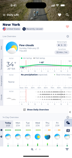
Sonuby offers pre-built weather reports such as Daily Life that allow you to focus on the forecasts that are relevant to you.
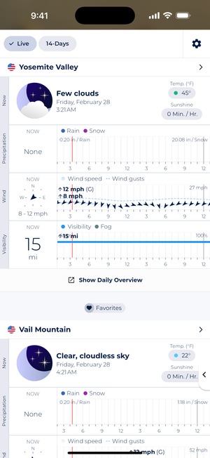
A variety of view modes, such as List View, make it easy to compare forecasts for different locations.
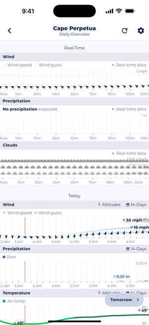
Daily Overview allows you to drill down to specific days and review conditions for specific days.
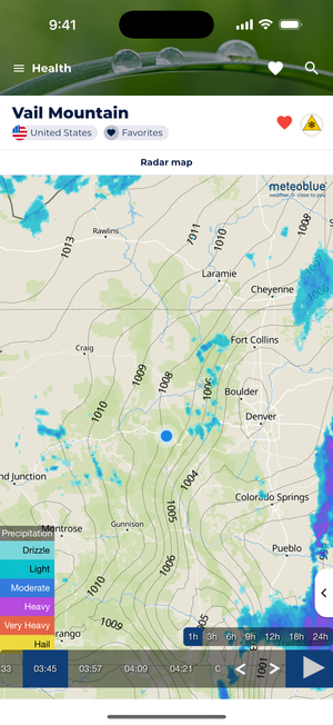
A wide variety of maps, such as the Radar Map, provide a detailed view of weather conditions.
Here’s your information formatted as a markdown table with columns of equal size:
| Pros | Cons |
|---|---|
| Highly reliable, worldwide forecasts (with a special focus on complex terrain in Western and Central Europe) | No multi-model or model selection (yet) |
| Forecasts available as: - Hourly and weekly tables - Comprehensive meteograms - Weather maps | Ad-supported in the free version |
| Most forecasts are free | |
| View forecasts in imperial or metric units, or Celsius or Fahrenheit for temperature, for quick and easy interpretation of results | |
| Available for iOS and Android |
The Weather Channel's forecasting system utilizes a combination of various weather models and proprietary algorithms. Their approach includes:
The Weather Channel incorporates data from multiple global and regional weather models, including the Global Forecast System (GFS), European Centre for Medium-Range Weather Forecasts (ECMWF), and their own high-resolution models.
They use a sophisticated data assimilation system that integrates observations from weather stations, satellites, radars, and other sources to improve forecast accuracy.
The Weather Channel employs artificial intelligence and machine learning techniques to enhance forecast accuracy and provide hyperlocal predictions.
Their system includes high-resolution models that can provide detailed forecasts for specific locations, particularly useful in areas with complex terrain or microclimates.
The Weather Channel regularly verifies its forecasts against observations and has consistently ranked among the top performers in forecast accuracy studies.
The Weather Channel's forecasts are particularly strong in:
The Weather Channel combines accurate forecasts with a user-friendly interface and additional features like severe weather alerts, lifestyle forecasts, and educational content.
The Weather Channel is a widely-used weather forecast app known for its comprehensive coverage and user-friendly interface.
It uses its own proprietary forecasting system, which has consistently ranked among the most accurate globally.
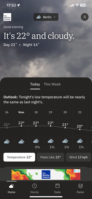
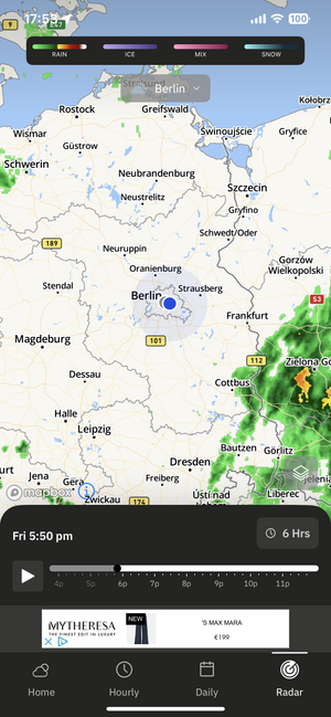
Here’s your information formatted as a markdown table with columns of equal size:
| Pros | Cons |
|---|---|
| Highly accurate forecasts, especially for North America | Ad-supported in the free version |
| Comprehensive coverage including hourly, daily, and extended forecasts | Some users report occasional issues with location accuracy |
| Interactive weather maps with various layers (radar, satellite, etc.) | Limited customization compared to some specialized weather apps |
| Severe weather alerts and real-time updates | |
| Lifestyle forecasts (e.g., allergy, flu, outdoor activities) | |
| Available for iOS and Android with a web version | |
| Free with optional premium features |
The Weather Channel app offers a balance of accuracy, comprehensive features, and ease of use, making it a popular choice for general weather forecasting needs.
Windy's approach to weather forecasting is unique in its transparency and multi-model offering:
Windy provides access to several global and regional weather models, including ECMWF, GFS, ICON, and NEMS. This allows users to compare forecasts from different sources.
The app offers high-resolution forecasts, with some models providing data at resolutions as fine as 1 km for certain regions.
Windy excels in data visualization, offering intuitive and interactive maps that display various weather parameters.
Forecasts are updated multiple times daily, ensuring users have access to the latest predictions.
Windy incorporates user-submitted weather reports, which can enhance local accuracy and provide real-time information.
Windy's forecasts are particularly useful for:
Windy offers unparalleled data visualization and model comparison, making it ideal for users who want to dig deeper into weather forecasts and understand the uncertainty in predictions.
Windy is a popular weather forecasting app known for its interactive maps and comprehensive data visualization.
It stands out for offering multiple weather models, allowing users to compare different forecasts.
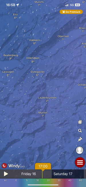
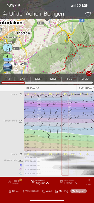
Here’s your information formatted as a markdown table with columns of equal size:
| Pros | Cons |
|---|---|
| Multiple weather models available for comparison | Can be overwhelming for casual users due to the amount of data |
| Highly interactive and visually appealing maps | Maps as the default visualization of forecasts may not be everyone’s preference |
| Detailed forecasts for wind, precipitation, temperature, and more | Some advanced features require a paid subscription |
| Excellent for marine, aviation, and outdoor activity forecasts | Occasionally slower to load compared to simpler weather apps |
| User-submitted weather reports for real-time information | |
| Available for iOS and Android with a comprehensive web version | |
| Most features available for free |
Windy is an excellent choice for weather enthusiasts, outdoor professionals, and anyone who wants to explore weather data in depth. Its multi-model approach and rich visualizations provide a unique and informative weather forecasting experience.
When it comes to reliable weather apps in 2026, Sonuby Weather, The Weather Channel, and Windy stand out as top choices. Each offers unique strengths:
The most reliable weather app for you depends on your specific location and needs. Consider factors such as data sources, forecast variables, and how well the app works in your geographic area. Keep in mind that while these apps strive for accuracy, weather forecasting is inherently complex and subject to some uncertainty, especially for longer-range predictions.
Ultimately, the best approach may be to try a few different apps and see which one consistently provides the most accurate forecasts for your location. By understanding what makes a weather app reliable and choosing one that meets your needs, you’ll be better equipped to plan your activities and stay prepared for whatever weather comes your way.